Improved location detection
Page updated: 7 January 2021
Technology offers significant potential to reduce the ‘search’ part of search and rescue, given improvements in the ability to locate people on land, water and in the air.
Location technology is improving rapidly
The range of technologies involved in finding people is improving significantly over time.
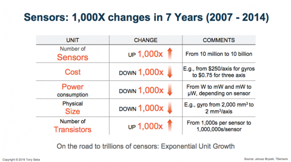
For example, locator beacons are getting ever more powerful and cheaper as the cost of sensors drops dramatically and both satellite imagery and drones improve. The rapid improvement in power and decline in the cost of such sensors in recent years is demonstrated below[i].

---
[i] Seba, T (2017). Clean Disruption Why Conventional Energy And Transportation Will Be Obsolete By 2030, http://www.swedbank.no/idc/groups/public/@i/@sc/@all/@lci/documents/presentation/cid_1987411.pdf.
Better location tech is enabling a shift from 'search' to 'rescue'
System improvements that improve the ability to correctly identify a person or vessel in trouble can save many hours. This can literally make the difference between life and death in some situations.
This is why the array of beacons for people and craft on land, on the water and in the air, is so important.
We know that the more that people have access to effective tracking devices that can locate their precise location, the more people use such devices to seek help when needed.
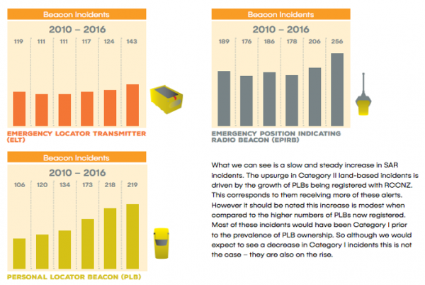
For example, in the figures below, we can see a slow and steady increase in SAR incidents with the upsurge in Category II land-based incidents driven by the growth of Personal Locator Beacons (PLBs) being registered with the Rescue Coordination Centre NZ (RCCNZ). This is a good thing because it suggests that the kinds of operations are indeed shifting from 'search' to 'rescue', saving both lives and resources.

Increased use of personal locator beacons making rescue easier
The trend towards more use of personal locator beacons is particularly encouraging given the increasing need to tackle tricky trends like the predicted increase in the number of older people wandering. As LandSAR put it:
“in the medium term, technological advancements will reduce the SAR component of the response, when vulnerable person strays or is noted as missing. Real-time GPS tracking or RFID monitoring will mean that subject locations will be known immediately, or very quickly, and a care-giver going and collecting them will be a more appropriate response than a SAR call out.”
Of course there are certain limitations of existing approaches to gathering and interpreting location data. For example, much data that would be useful for locating people on land is often not available because either a person does not have a beacon or has failed to register it. That said, certain members of the SAR sector are highly optimistic about uptake in future, commenting:
“We expect a lot more beacon and satellite messenger uptake without any additional promotion or change of approach. I would anticipate 80% of backcountry users carrying PLBs within 5 years. RFID tagging…will become a significant tool (e.g. The introduction of the flyable Recco detection system for wilderness SAR).”[i]
---
[i] LandSAR (2017). Feedback on the draft NZSAR environmental scan, received via email, 23 November 2017, 8.26AM.
In future, relying more on systems rather than individual choices may be wiser
One thing the SAR sector may wish to reflect on is how much to leave to the choices made by individuals or individual entities and how much to build into systems and processes so that carrying a locator beacon becomes automatic.
We can easily illustrate what can happen when decisions about whether to carry a locator beacon are left to individuals or individual organisations. For example, traditional approaches to tracking the positions of aircraft (radar, transponder, Automatic-Dependent Surveillance Broadcast) have come under scrutiny recently when MH370 was able to disappear without a trace.[i]
Extrapolating from this, we might expect improved ability to locate people in the future to be realised by :
- improving satellite-based communication generally, making it easier to locate people;
- extending wider cell phone coverage; and
- encouraging more recreation closer to cities where coverage is likely to be better.
- ensuring devices are both easily accessible and available to the public and organisations operating in the outdoors.
The SAR sector is already systematising new technologies in a number of areas to improve its effectiveness. For example, a new distress signalling system was introduced a few months ago that automatically provides the location of the signal. As one staff member put it “we’re becoming less search and more rescue. This is great because it leads to better outcomes.”
Tracking systems like SARTrack[ii] and SKYTRAC[iii] also offer the ability to improve the quality of tracking by exploiting the increasing availability of satellite imagery. Next generation tracking technologies are likely to improve exponentially in the coming decade and are worth NZSAR Secretariat monitoring continuously to establish opportunities to improve its capability in this critical area.
---
[i] Simon Calder Travel Correspondent. “MH370: New Crash Site Identified for Missing Boeing 777 Plane, Say Scientists.” The Independent, Independent Digital News and Media, 17 Aug. 2017, www.independent.co.uk/travel/news-and-advice/mh370-missing-plane-search-malaysia-airlines-flight-boeing-777-new-crash-site-identified-a7897586.html.
[ii] Picken, Dawn. “New Tech Tool for Search and Rescue.” NZ Herald, 1 Oct. 2016, www.nzherald.co.nz/nz/news/article.cfm?c_id=1&objectid=11719242.
[iii] “SkyTrac: Aviation Awareness and Data Management.” Skytrac, 26 Apr. 2017, www.skytrac.ca/.
